Exploring the Eastern Sierras
When: 2017-07-01 to 2017-07-04
Virginia Lakes Basin
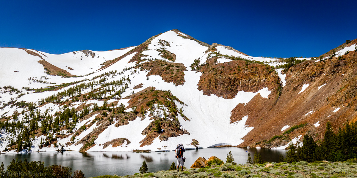
|
Francisco near Big Valley Lake. |

|
View of Blue Lake. |

|
Looking back at Blue Lake from the trail. |

|
Water levels rushing around Cooney Lake. |

|
On the shores of Cooney Lake. |

|
Francisco crossing snow fields at 10,600 ft. |
At this point, we passed by several lakes without refilling our water. Expecting to have come across another water source by now, we severely miscalculated. In a last ditch effort, we spent time melting snow on slabs of rocks and watched the droplets fall into the bottles. Add to the situation a pounding headache, and we have a very uncomfortable situation.

|
Melting snow by sunlight. |
With the headache still around, gaining the ridge via the talus field took an embarassing amount of time.

|
Summit Lake, as seen from the pass. |

|
The space between Camiaca Peak and Gabbro Peak. |

|
Francisco on Summit Pass, with Summit Lake in the distance. |

|
Looking back at the Virginia Lake Basin, Mt. Olsen, and Black Mountain. |

|
Francisco photographing the Virginia Lakes. |
On the way back down from the ridge, we descended talus, scree, and fields of suncups down to Frog Lakes.

|
Heart. |

|
Francisco near Frog Lakes. |
Convict Lake

|
Table acting as a bridge. |

|
Laurel Mountain and Convict Lake. |

|
Fishing at Convict Lake. |

|
On the Convict Lake loop. |
The southwest side of the trail was flooded, so we decided to take a detour in an effort to avoid needless water crossings. Instead, we walked into a lot of bushwhacking and--surprise--even stronger water currents to cross.

|
Hai with his camcorder. |

|
Photo shoot by the creek. |

|
Chimping by the creek. |

|
Yet another photo shoot. |

|
Hai. |
Deciding to head back to the trail and deal with the calmer water levels, we turned back to where we made our original detour.

|
Starting off, once again. |
Back on trail, we did have to get our feet wet.

|
Waterfall off the boardwalk. |

|
Convict Lake from the southwest side. |
Back on trail, we found several butterlies congregating near the lake.

|
Ground level photography. |

|
On trail to Dorothy Lake. |

|
A chipped lunch. |
We ended up finding a nice spot to take a break in the shade, across the trail from a large talus field which lead up to a potential climbing route.

|
A talus approach to an improbably climb. |

|
Looking out from the middle of a talus field. |
Francisco managed to walk all the way up the talus field and scouted out some of the climbing routes that we were brainstorming.

|
Scouting routes. Route scouting. |
While Francisco was up climbing, I had his 150-600 for some reach and bokeh.

|
Francisco on the descent. |
Afterwards, Hai started up the talus field to see how far he would get.

|
Hai on talus. |

|
Descending. |
Still on our break, Francisco and I went to explore a possible path leading to another ridge.

|
Snowy slip and slide. |

|
Descending; back to Hai. |
Rather than going all the way to Lake Dorothy, we decided to turn back due to the time. On the trail back, we noticed that there was a healthy sized boulder off to the side. Obviously, we had to climb it.

|
Topping out. |

|
Convict Lake with a heart perspective. |
Rather than go around the other end of the loop to get back to our car, we just went through the water. On the way back, it appeared that the water levels rose from earlier.

|
Hai crossing the boardwalk, Francisco recording behind. |

|
Francisco recording the boardwalk waterfall. |

|
Convict Lake, again. |
After dinner at the Mobil station, we stopped by Mono Lake.

|
Tufa sunset. |

|
An offset Mono Lake. |

|
Flying. |

|
Sunset at Mono Lake. |

|
Orange and blues. |
After arriving back to our campsite, we decided to wake up around 2:30 A.M. for a shot at some night photography.

|
Convict Lake at night. |

|
Convict Lake at night (2). |
Mt. Dana

|
Francisco on the trail near the end of the tree line. |
Above the tree line and below the talus fields, we ended up crossing creeks several times. Learning from the experiences of dehydration at Virginia Lakes, we decided to refill our water before it got too late. To be safe, we were a bit more prepared this time and carried a stove up there in addition to a water filter.

|
Francisco looking for bees. |
The remainder of the route involved talus and suncups; there was a constant trade-off between navigating through one or the other.

|
Patches of suncups. |
All throughout, the trail was hit-or-miss in terms of visibility. At some point, I decided to simply go up. This decision was made, in part, because I failed to find the trail.

|
View from the ridge, looking toward Mono Lake. |
While traversing the ridge to the summit trail, I found Francisco on his way down from the summit where he was waiting for a while.

|
Francisco, on the way down. |

|
Supporting a flag with one of the many cairns marking the trail. |

|
Yet another missed cairn, marking the trail. |

|
Looking for views on the descent. |

|
Mammoth Peak and Kuna Crest. |